
PROJECTS
PROJECTS
Our scientists have decades of experience performing biological surveys, writing biological reports, developing government permit applications, informing agency policy decisions, and implementing monitoring protocols and complex regulatory requirements for aquatic and shoreline ecosystems throughout Western Washington. MSA is well known for our ability to work with a wide variety of stakeholders and agencies to communicate in an effective manner. Our close-knit team of biologists and project managers retain the flexibility and responsiveness that is possible with a smaller group while maintaining the capacity to work on large projects. With a full-time financial manager as part of our crew, we have the ability to execute complex projects and ensure that budgets do not exceed their contracted amounts or scope. Because we are known for our quick turn-around times and quality service, we have standing contracts with marine development companies and have been on-call biologists with the Hood Canal Coordinating Council, Port of Seattle, Ocean City State Park, and WDFW. we have been chosen as the on-call biological consultants for many land use, construction, and development companies throughout the area. MSA also has experience working with several port districts (Brownsville, Silverdale, Kingston, Winslow, Port Angeles, and Port Townsend) to provide biological consulting services.
PROJECTS
Our scientists have decades of experience performing biological surveys, writing biological reports, developing government permit applications, informing agency policy decisions, and implementing monitoring protocols and complex regulatory requirements for aquatic and shoreline ecosystems throughout Western Washington. MSA is well known for our ability to work with a wide variety of stakeholders and agencies to communicate in an effective manner. Our close-knit team of biologists and project managers retain the flexibility and responsiveness that is possible with a smaller group while maintaining the capacity to work on large projects. With a full-time financial manager as part of our crew, we have the ability to execute complex projects and ensure that budgets do not exceed their contracted amounts or scope. Because we are known for our quick turn-around times and quality service, we have standing contracts with marine development companies and have been on-call biologists with the Hood Canal Coordinating Council, Port of Seattle, Ocean City State Park, and WDFW. We have been chosen as the on-call biological consultants for many land use, construction, and development companies throughout the area. MSA also has experience working with several port districts (Brownsville, Silverdale, Kingston, Winslow, Port Angeles, and Port Townsend) to provide biological consulting services.
PROJECTS
Our scientists have decades of experience performing biological surveys, writing biological reports, developing government permit applications, informing agency policy decisions, and implementing monitoring protocols and complex regulatory requirements for aquatic and shoreline ecosystems throughout Western Washington. MSA is well known for our ability to work with a wide variety of stakeholders and agencies to communicate in an effective manner. Our close-knit team of biologists and project managers retain the flexibility and responsiveness that is possible with a smaller group while maintaining the capacity to work on large projects. With a full-time financial manager as part of our crew, we have the ability to execute complex projects and ensure that budgets do not exceed their contracted amounts or scope. Because we are known for our quick turn-around times and quality service, we have standing contracts with marine development companies and have been on-call biologists with the Hood Canal Coordinating Council, Port of Seattle, Ocean City State Park, and WDFW. we have been chosen as the on-call biological consultants for many land use, construction, and development companies throughout the area. MSA also has experience working with several port districts (Brownsville, Silverdale, Kingston, Winslow, Port Angeles, and Port Townsend) to provide biological consulting services.
Slide title
Write your caption here
Button
Selected Projects
Mariners Cove Beach Club Marine Dredge project,
Oak Harbor, WA. 2018 – present
Mariners Cove is a residential community located on the shores of Puget Sound. This community marina needs to be periodically dredged to maintain access and use for its members. In the time between maintenance dredges native eelgrass colonizes areas within the marina. Eelgrass (Zostera marina) is considered a saltwater habitat of special concern in Washington State, so a management, mitigation, and monitoring plan has been developed and implemented, including transplant and monitoring of Z. marina. Monitoring parameters for eelgrass are very similar to that of terrestrial plants in which aerial coverage and plant numbers are measured. To satisfy permit requirements, the annual monitoring report also includes a statistical analysis assessing success and recovery of eelgrass between each monitoring event. In addition to eelgrass management, sediment chemistry is sampled to determine where the dredged material is proposed to be placed post-dredging. Future surveys may be needed for placement of dredge materials on the beach, upland, or in approved open-water sites.
North Beach Outfall Replacement Project,
Port Townsend, WA. 2019 – Present
Marine Surveys & Assessments partnered with Jacobs Engineering on an outfall replacement project for the City of Port Townsend at North Beach Park. MSA conducted a Submerged Aquatic Vegetation (SAV) Survey for quantitative density data in conformance with the protocols approved by WDFW, and DNR, and USACE. The SAV Survey results were used to determine where the new outfall pipe should be placed to have the least amount of environmental impact on the native vegetation. GIS mapping and data analysis helped refine the placement of the proposed pipe. Habitat Mitigation and Monitoring Plan was developed for eelgrass, kelp, and surf grass to achieve minimal temporal and spatial impacts and to employ the most successful transplant methods. Long-term monitoring will be required to evaluate the re-establishment of the kelp, seagrass, and eelgrass habitat.
Olympic Water and Sewer Geoduck Survey, Port Ludlow, WA. 2017
Olympic Water and Sewer operates a Wastewater Treatment Plant at the mouth of Port Ludlow Bay in North Hood Canal. Marine Surveys & Assessments conducted a wide-scale survey to establish current geoduck density in the overlapping area of the commercial geoduck zone and the Port Ludlow Outfall Prohibited Area (approximately 679 acres). The purpose of the survey was to ensure that the DNR resource revenue loss calculation impacting Olympic Water and Sewer be based on the most current and accurate geoduck density data. MSA utilized previously established WDFW geoduck survey protocol to implement a 148 transect survey to provide a more representative sampling of this overlapping zone. A siphon show-plot was established to the south of the survey, and the show plot was revisited on each day the survey took place in order to determine show factors and adjust observed densities within the survey. GIS mapping and a survey report were also provided.
North Olympic Salmon Coalition/Kodama Farm,
Chimacum, WA. 2018
Marine Surveys & Assessments was contracted by the North Olympic Salmon Coalition (NOSC) to conduct a wetland delineation to determine wetland boundary lines at Kodama Farm in Chimacum Valley, Washington. The wetland boundaries were flagged during the delineation to determine buffers and building setback lines. The delineation and subsequent rating provided the client with the necessary information for future development. A wetland delineation report was then completed with a wetland rating, including GIS mapping, for submittal to Jefferson County.
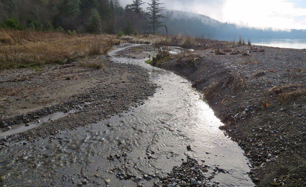
Ocean City State Park, Wetland and Hydrological Study, WA. 2021
A wetland, stream, groundwater, and habitat study to gather data to help determine the root cause(s) of Ocean City State Park’s history of flooding problems. By gaining a better understanding of the surface water hydrology system, the park is hoping to develop a more informed management plan for the future. The park has several factors that make determining the source of the flooding difficult, including sea level rise, invasive yellow flag iris and beaver dams clogging the streams, new development to the north, and a discontinuation of dredge work that used to be conducted in the drainages.
Jamestown Tower LLC; Jamestown S’Klallam Tribe, Sequim, WA June 2019
Marine Surveys & Assessments conducted a Habitat Survey assessing upland habitat, wildlife, and vegetation, along with a wetland determination and GIS mapping for a proposed telecommunication tower and gravel utility road. A Biological Assessment was then completed to comply with the Federal Communication Commission’s National Environmental Policy Act (NEPA) criteria to evaluate potential impacts to threatened or endangered species and associated critical habitat.
Tesoro Eelgrass Monitoring Project. Anacortes, WA. 2018
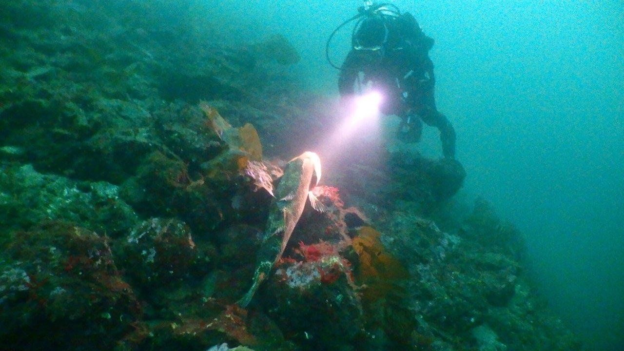
Marine Surveys & Assessments was contracted by Tesoro Oil and Gas to conduct biennial monitoring for eelgrass densities along a 2,500 ft section of a transfer causeway. Lead Scientific Diver Bryan De Caterina led a team of four MSA divers to survey the habitat and record eelgrass densities. MSA handled all preparational logistics, mapping, data collection and transcription, monitoring, and report writing for this project.
Mariners Cove Beach Club Marine Dredge project, Oak Harbor, WA.
2018 – present
Mariners Cove is a residential community located on the shores of Puget Sound. This community marina needs to be periodically dredged to maintain access and use for its members. In the time between maintenance dredges native eelgrass colonizes areas within the marina. Eelgrass (Zostera marina) is considered a saltwater habitat of special concern in Washington State, so a management and mitigation plan has been developed and implemented, including restoration of eelgrass habitat after dredging. Monitoring parameters for eelgrass are very similar to that of terrestrial plants in which aerial coverage and plant numbers are measured. To satisfy permit requirements, the annual monitoring report also includes a statistical analysis assessing success and recovery of eelgrass between each monitoring year. In addition to eelgrass management, sediment chemistry is sampled to determine where the dredged material is proposed to be placed post-dredging. Future surveys may be needed for placement of dredge spoils on the beach, upland or in approved deep-water sites.
Mariners Cove is a residential community located on the shores of Puget Sound. This community marina needs to be periodically dredged to maintain access and use for its members. In the time between maintenance dredges native eelgrass colonizes areas within the marina. Eelgrass (Zostera marina) is considered a saltwater habitat of special concern in Washington State, so a management and mitigation plan has been developed and implemented, including restoration of eelgrass habitat after dredging. Monitoring parameters for eelgrass are very similar to that of terrestrial plants in which aerial coverage and plant numbers are measured. To satisfy permit requirements, the annual monitoring report also includes a statistical analysis assessing success and recovery of eelgrass between each monitoring year. In addition to eelgrass management, sediment chemistry is sampled to determine where the dredged material is proposed to be placed post-dredging. Future surveys may be needed for placement of dredge spoils on the beach, upland or in approved deep-water sites.
North Beach Outfall Replacement Project, Port Townsend, WA 2019 – Present
Marine Surveys & Assessments partnered with Jacobs Engineering on an outfall replacement project for the City of Port Townsend at North Beach Park. MSA conducted a Submerged Aquatic Vegetation (SAV) Survey for quantitative density data in conformance with the protocols approved by WDFW, and DNR, and USACE. The SAV Survey results were used to determine where the new outfall pipe should be placed to have the least amount of environmental impact on the native beds vegetation. GIS mapping and data analysis helped refine the placement of the proposed pipe. Eelgrass, kelp and surf grass transplantation surveys were done, and a Habitat Mitigation and Monitoring Plan was developed to ascribe the least temporal and most successful transplant methodologies to return the impacted site to its previous condition. Long-term monitoring will be required to confirm re-establishment of the kelp, seagrass, and eelgrass habitat.
Ocean City State Park, Wetland and Hydrological Study, WA. 2021
A wetland, stream, groundwater, and habitat study to gather data to help determine the root cause(s) of Ocean City State Park’s history of flooding problems. By gaining a better understanding of the surface water hydrology system, the park is hoping to develop a more informed management plan for the future. The park has several factors that make determining the source of the flooding difficult, including sea level rise, invasive yellow flag iris and beaver dams clogging the streams, new development to the north, and a discontinuation of dredge work that used to be conducted in the drainages.
Olympic Water and Sewer Geoduck Survey, Port Ludlow, WA. 2017
Olympic Water and Sewer operates a Wastewater Treatment Plant at the mouth of Port Ludlow Bay in North Hood Canal. Marine Surveys & Assessments conducted a wide-scale survey to establish current geoduck density in the overlapping area of the commercial geoduck zone and the Port Ludlow Outfall Prohibited Area (approximately 679 acres). The purpose of the survey was to ensure that the DNR resource revenue loss calculation impacting Olympic Water and Sewer be based on the most current and accurate geoduck density data. MSA utilized previously established WDFW geoduck survey protocol to implement a 148 transect survey to provide a more representative sampling of this overlapping zone. A siphon show-plot was established to the south of the survey, and the show plot was revisited on each day the survey took place in order to determine show factors and adjust observed densities within the survey. GIS mapping and a survey report were also provided.
North Olympic Salmon Coalition/Kodama Farm, Chimacum, WA. 2018
Marine Surveys & Assessments was contracted by the North Olympic Salmon Coalition (NOSC) to conduct a wetland delineation to determine wetland boundary lines at Kodama Farm in Chimacum Valley, Washington. The wetland boundaries were flagged during the delineation to determine buffers and building setback lines. The delineation and subsequent rating provided the client with the necessary information for future development. A wetland delineation report was then completed with a wetland rating, including GIS mapping, for submittal to Jefferson County.
Ordinary High Water Mark (OHWM) Determination and Stream Typing for InPeak Properties, Poulsbo, WA. October 2019
MSA performed an Ordinary High Water Mark (OHWM) determination including GIS and stream typing to determine how far upland the stream buffer would extend, informing clients of buffers and building setback lines. MSA also worked with the clients to develop a potential landscape and vegetation restoration plan to offset any impacts. For OHWM determinations and stream typing, a strong background in native vegetation (specifically vegetation found in “Western Mountains, Valleys, and Coast Regions”) is required.
Jamestown Tower LLC; Jamestown S’Klallam Tribe, Sequim, WA June 2019
Marine Surveys & Assessments conducted a Habitat Survey assessing upland habitat, wildlife, and vegetation, along with a wetland determination and GIS mapping for a proposed telecommunication tower and gravel utility road. A Biological Assessment was then completed to comply with the Federal Communication Commission’s National Environmental Policy Act (NEPA) criteria to evaluate potential impacts to threatened or endangered species and associated critical habitat.
Tesoro Eelgrass Monitoring Project. Anacortes, WA. 2018
Marine Surveys & Assessments was contracted by Tesoro Oil and Gas to conduct biennial monitoring for eelgrass densities along a 2,500 ft section of a transfer causeway. Lead Scientific Diver Bryan De Caterina led a team of four MSA divers to survey the habitat and record eelgrass densities. MSA handled all preparational logistics, mapping, data collection and transcription, monitoring, and report writing for this project.
Selected Clients
- Ashton Engineering Inc.
- Aspect Consulting
- Bellingham Marine
- Bridgehaven Community Club
- City of Bainbridge Island
- City of Gig Harbor
- City of Kenmore
- City of Oak Harbor
- City of Port Townsend
- Coastal Geologic Services
- Davido Consulting Group
- ECCO Architecture & Design
- Elwha River Fish Company
- Fain Environmental
- Hama Hama Oyster Company
- Hayley & Aldrich
- Hood Canal Coalition
- Hood Canal Coordinating Council
- JA Brennan Associates
- Jacobs Engineering
- Jefferson County
- Jefferson County Land Trust
- Jefferson County Marine Resources Committee
- Jefferson County Public Utility District
- Kala Point Owners' Association
- Lakeshore Construction
- Lummi Nation
- Marathon Oil
- Marine Floats Corporation
- Mariners Cove Beach Club
- Northwest Straits Foundation
- Northwest Watershed Institute
- PND Engineers
- Port Gamble S'Klallam Tribe
- Port of Brownsville
- Port of Friday Harbor
- Port of Kingston
- Port of Port Angeles
- Port of Port Townsend
- Port of Poulsbo
- Port of Silverdale
- Port of South Whidbey
- Port Townsend Paper Company
- Reid Middleton Engineers
- Sealevel Bulkhead Builders
- Skyline Marina
- Studio STL
- Stratum Group
- Tahuya Basin and Channel Owners Association
- Tetra Tech
- Trident Marine Services
- Tulalip Tribes
- U.S. Navy
- Washington Department of Natural Resources
- Washington Department of Transportation
- Washington State Parks
- Waterfront Construction
- Whatcom Waterfront Construction
© MARINE SURVEYS & ASSESSMENTS COOPERATIVE
© MARINE SURVEYS & ASSESSMENTS COOPERATIVE